Western Way in Mayo and Galway now part of International Appalachian Trail
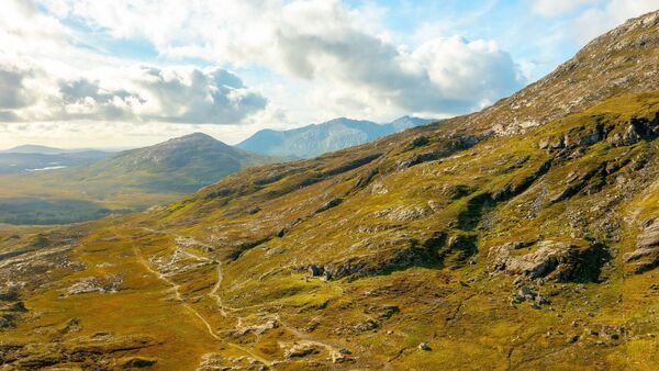
A drone shot of Mám Éan.
The Western Way national trail in the Mayo/Galway border region is now part of the International Appalachian Trail (IAT). The IAT was founded in the 1990s and was first considered an extension of the Appalachian Trail in the USA and the Canadian Appalachian range.
The Western Way is a long-distance walking trail taking in spectacular scenery. The trail begins in Oughterard, Co Galway and finishes near Bonniconlon. It has ancient connections to routes used by our ancestors. It became part of the national walking trails system in the 1980s, taking in spectacular scenery in both two counties. Mám Éan is located at the ancient pass crossing the Maumturks mountains between the Maam Valley and the Inagh Valley. Ireland shares a geological history with the USA and Canada, and also Scotland, Scandinavia and Greenland. There is ample evidence in the rocks along the trail revealing these strong connections.

The newly named ‘Mám Éan Geotrail’ consists of three information panels, two at either side of the pass and one at the col (the saddle between the two ridges), which explores the geological links between the west of Ireland and northeastern America.
The Atlantic Ocean is only about 100 million years old. Before then, the two continents North America and Europe were linked. The Appalachian Range in the USA extends into the mountain ranges of Galway, Mayo and Donegal and the mountains of Scotland then (called the Caledonides). These geological connections are particularly emphasised at Mám Éan in Galway in the Joyce Country and Western Lakes Geopark.
The Mám Éan Geotrail offers a great asset for the JCWL Geopark and the communities of Maam, Recess and Leenane, expanding the interpretation already offered in the geopark region. It shines a new light on the prime outdoor tourism infrastructure that is the Western Way and connects it to North America through the IAT, not only through human connections but also thanks to its geology.
The Mám Éan Geotrail was commissioned by JCWL GeoEnterprise, funded by Geological Survey Ireland’s GeoHeritage grant, and produced by the JCWL Geopark in association with Comharchumann Dhúiche Sheoigheach Teo, in partnership with National Parks and Wildlife Services and County Galway Rural Recreation Officer based in Forum Connemara.

The Mám Éan Geotrail was launched last month at Ionad Pobail an Mháma with two guest speakers, Brian McConnell, retired principal and geologist at Geological Survey Ireland, who highlighted the geological connections with North America, while Frank Conroy gave a fascinating account of the history and folklore linked with Mám Éan and its use down through the ages by locals in Maam. It was followed by a well-attended guided walk over the length of the Geotrail, led by Benjamin Thébaudeau the Geopark geologist, Mr McConnell and Carole Reynolds of Connemara National Park.


