Mayo/Galway Geopark project gets major UNESCO boost

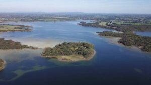
The territory of Joyce Country and Western Lakes Geopark includes Loughs Carra (pictured).
In a major step towards a highly-prized international designation, Joyce Country and Western Lakes Geopark in north Galway and south Mayo has just been granted UNESCO Global Geopark status at the 10th UNESCO Global Geoparks Council meeting in Temuco, Chile. This decision will be ratified at the UNESCO executive board meeting in Paris early next year.
This will be the first UNESCO Global Geopark in Connacht and the first on the island of Ireland to include a Gaeltacht (Dúiche Sheoigheach agus Tuar Mhic Éadaigh).
The globally significant UNESCO brand will put north County Galway and south-west Mayo on a positive trajectory for enhanced local community development and jobs.
Since 2014, the city of Galway has held UNESCO status as a City of Film, as part of the UNESCO Creative Cities Network. This is the first accolade for Mayo for UNESCO designation.
Currently, there are 229 UNESCO Global Geoparks worldwide, with many in Europe. The four on the island of Ireland are the Burren and Cliffs of Moher (County Clare), Cuilcagh Lakelands (Fermanagh/Cavan), Copper Coast (Waterford), and Mourne Gullion Strangford (Down/Armagh). The status brings membership of the Global Geoparks Network to 50 countries, also including Asia, the Americas and Africa.
A UNESCO Global Geopark uses its geological heritage, in connection with all other aspects of its natural and cultural heritage, to promote and develop its communities sustainably in a bottom-up way. They attract visitors to explore and experience the physical, cultural and other features of the area.
Geoparks enhance awareness and understanding of key issues facing society, such as using our earth’s resources sustainably, mitigating the effects of climate change and reducing natural hazard-related risks. UNESCO Global Geopark status adds no further planning regulations to those already in place.
The territory of Joyce Country and Western Lakes Geopark, which includes Loughs Carra, Mask and the northern half of the Corrib, is renowned for its outstanding beauty. This stunning landscape has evolved from 700 million years of geological activity, and since the last ice age 12,000 years ago from dedicated farming and landscape management.
Better known towns and villages in the region include Ballinrobe, Cong, Clonbur, Headford, Leenane (Wild Atlantic Way) and Oughterard – all of which have fascinating geosites, local tourism attractions and stunning walking/cycling trails. The villages of Aughagower (round tower), Ballintubber (Abbey), Carnacon, Corr na Móna, Cross, Finny (Lough Nafooey), Glencorrib, Killawalla, Maam, Maam Cross, The Neale (Boycott story), Partry, Recess/Inagh Valley, and Tourmakeady (waterfall) offer an abundance of things to see and do, stemming from their picturesque landscapes.
UNESCO status is the result of many years’ work on the ground by local communities, the Geopark staff and continued financial support from Údarás na Gaeltachta, Geological Survey Ireland, Mayo and Galway County Councils, in association with Fáilte Ireland, National Parks and Wildlife Service, Coillte and Inland Fisheries Ireland. Collaboration and cooperation have been central to driving this initiative.


