Water quality in Mayo's rivers and lakes above national average

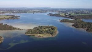
Lough Carra is one of the priority action areas in Mayo for the Local Authority Water Programme.
Water quality in Mayo's rivers and lakes is among the best in Ireland, standing at 67% compared to the national average of 54%. However, factors such as agriculture, urban wastewater and forestry are impacting water flow, members of Mayo Co Council's Environment Strategic Policy Committee (SPC) were informed at a recent meeting.
The details of the current water action plan for Mayo, which is covered by the Water Framework Directive, was outlined to the SPC by Bernadette White from the Local Authority Water Programme.
Explaining that the plan was launched last September as part of a government commitment to protect and restore all water bodies and, more importantly, the catchments that feed into them, Ms White noted there are 46 catchment management plans in Mayo, which would include the Moy and Erriff rivers as well as waters flowing into the various bays, such as Clew Bay and Killala Bay.
Under a national agriculture inspection programme, 4,500 farms have already been inspected, she said, while it is also hoped to bring 15,000 farmers into the voluntary Teagasc Farming for Water scheme, which offers nature-based solutions to protect water quality.
In terms of the quality of water in Ireland at the moment, she said just 54% of rivers were achieving the required standards nationally. However, in Mayo, it stands at 67%, which is much welcomed and the focus is therefore to maintain it.
There are also more high-status waters in Mayo, she said, with 18% in the county achieving this, which marked a slight decline from previous years.
“We do have some poor areas scattered across the county and will be working on those over next few years. However, it is important to consider the scale of the pressures on our waters.”
The number one pressure on Mayo rivers is caused by hydromorphology, i.e. where manipulation such as over-deepening or widening has impacted the shape of our rivers, cutting them off from floodplains or maybe straightening their paths through areas where they can’t flow. Agriculture is the next biggest pressure followed by other factors such as forestry and urban wastewater.
Ms White noted that several implementation and special interest bodies were working together on programmes around the county, including Mayo County Council, the National Federation of Group Water Schemes, the Office of Public Works (OPW), Uisce Éireann and Teagasc.
“In Mayo, the priority areas for action include Lough Carra and Lough Mask, waters in the area around Castlebar, Newport etc, so there is good coverage of the county and we work collaboratively with the council and agencies on a lot of these”, she said.
She added that Mayo Co Council is also working actively on its Local Authority Water Action Plan (LAWPRO), collaborating with the Environmental Protection Agency (EPA) through the inspection of domestic waters and promotion of the Climate Action and Biodiversity Plan.
“For us, the monitoring and reporting by all the bodies is key but has not been happening as well as it could have over the last few years. We have a water framework directive operating committee in the west and we are working with communities and basically giving them more power to work on this and also we have a number of funding streams under the community water development fund.”
A Lough Carra community group, as well as a climate action group in Louisburgh and the Kiltimagh Amenity Park, were just some beneficiaries of such grants, she said, adding that there is also a catchment support fund, which covers the core costs for a group to hire a dedicated water officer. She added that there are also promotional activities such as the Mayo Blue Dots programme, where high-quality waters are celebrated.
Responding to planned studies mentioned for the Bunowen and Carrowniskey rivers near Clew Bay, Ms White said these will entail looking at the ecology in order to identify nature-based solutions. Consultants will measure the shape, width, depth, slope and drainage connected to the rivers, assessing gravel levels and looking at the whole catchment with a view to the most cost-effective measures for drainage and water quality.


